Reformatted on 2025-12-10
1. Introduction1
Mountains are often perceived as a much more hostile or “severe” environment than lowlands. While I was recently reading a book by D. Keys (1999) Catastrophe: An Investigation into the Origins of the Modern World I realised that this negative perception of mountains must be qualified. It is indeed often the case, in temperate countries, that life is harsher for plants, animals and humans alike at higher elevations, but the reverse can apply in tropical countries. See Driven into the mountains for some examples.
2. Climatic characterisation of mountains
Overview
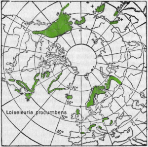
Climate variables undergo systematic changes with elevation, most notably a decrease in temperature. It is often argued that the altitudinal belts parallel latitudinal climate variations, but this applies only as a first approximation, as changing slope, aspect and other effects play a part as well. It remains that many plants and animals have disjunct distributions, i.e. they are found both in boreal and mountainous areas (hence the terminology: boreo-alpine plants; see Figure 2 for an example).
To describe mountain climates, scientists resort to standard climatic variables (rainfall, temperature…) but also need to include some variables which are usually considered constant al low elevations: atmospheric pressure (A) carbon dioxide (CO2, B) and UVB (C). In addition mountain climates are also characterised by a rather distinctive combination of temperature, radiation, wind and rainfall patterns, as well as a larger variability of climate, both spatial and temporal (at scales from days to seasons) compared with lowlands at the same latitude. A special mention of spatial variability is given as point D. .
A. Atmospheric pressure decreases with altitude in a very regular fashion. Although the values may be affected by moisture content and temperature, the “standard” atmosphere yield the following pressure values, in % of the atmospheric pressure at sea level: 89 % at 1000 m, 78 % at 2000 m, 60% at 3000 m and 53 % at 5000 m. The low pressure has an effect on the sublimation of ice, i.e.the rate at which ice transforms directly into the gaseous air moisture proceeds faster at low pressures, so that there is an additional loss of water at high elevations compared with lowlands. As a result, the amount of water that is actually available for runoff, plant life etc is less that the reported amount measured with raingauges. According to MacDonald et al. (2010) sublimation can amount to 20 % of the mass of snow, sometimes significantly more. Hood et al. (1999) report similar figures corresponding to water loss equivalent to close to 200 mm. If we include the work of Pomeroy et al. (1999), we can conclude that the amount of water lost to sublimation is very significant and frequently reaches 10 to 50% of snow.
B. Now to CO2: due to its molecular weight being larger than that of oxygen (O2), the abundance of CO2 relative to O2 (concentration of CO2 / concentration of O2) tends to decrease with elevation. Other things being equal, the decreased availability of CO2 both in absolute and relative terms poses some problems to the photosynthesis of plants and constitutes one of the factors of the relatively low productivity of mountain climates.
C. It is also worth mentioning UV-B radiation, which is typically 2 to 4 times more intense at high elevations than in the lowlands. Nanism of some plants is often quoted as one of the consequences.
D. The main feature of mountain climates, however, is their spatial variability: within short ranges, depending on slope, aspect (orientation of the slope) and elevation, soils and vegetation can change dramatically,
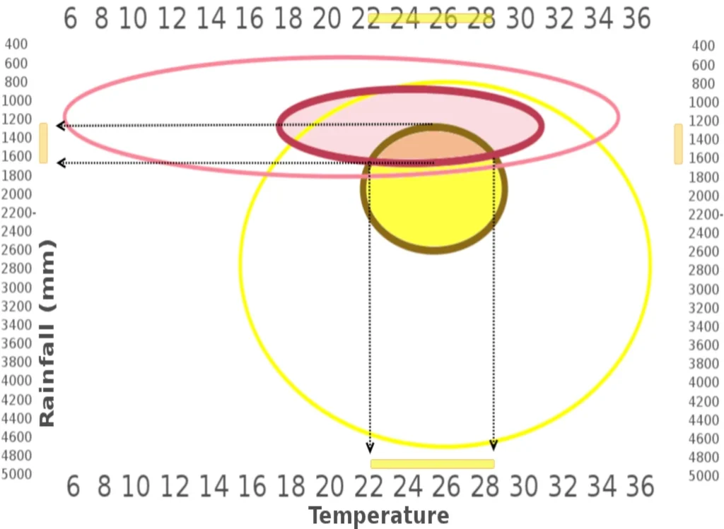
as does the crops that can be grown. A a result, at least potentially, mountains can produce a larger variety of foodcrops that lowlands. In Bhutan, I was very surprised to see bananas and plums growing side by side. When I told agronomists about this, they had some difficulties understanding how a temperate and a tropical crop could share the same field. Eventually, met a Moroccan agronomist who confimed that my observation was a common occurrence in the mountains of southern Morocco. Figure 3 illustrates how the ecophysiological characteristics of plums and bananas overlap in a narrow range, which farmers have discovered empirically.
Temperature and winds
Temperature normally decreases with elevation, mainly because the source of heat is the solar energy absorbed by the soil and re-radiated into the atmosphere as thermal radiation. The lower temperatures are thus a direct consequence of the decreasing atmospheric pressure. The change in temperature as a function of elevation is normally about 0.6 ºC per 100 m, but it may vary significantly as a function of moisture, temperature, etc. It is relatively low (0.5ºC per 100m) for wet air (i.e. air saturated with water, as in clouds) and 1º C for “dry” air (below 100%moisture).
When atmospheric conditions are stable (usually high atmospheric pressure and little wind), it occurs frequently that cold air accumulates in low-lying areas (valleys and other depressions), so that we observe an inversion of the “normal” temperature pattern. Such temperature inversions are often characterised by fog (the name given to clouds when they touch the surface of the earth) and risk of frost (see Appendix 2). Above the inversion the normal decrease with altitude starts again, so that the area just above the inversion is often referred to as a “warm belt”, usually well-known to local farmers.
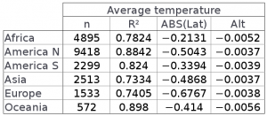
At the zonal scale, temperature depends mainly on latitude and elevation, and a large fraction of temperature variability can be explained by these two factors. Temperature decreases with altitude in a very predictable way, by about 0.0052 degrees/meter in Africa, which is about 5.2 degrees every thousand meters. This lapse rate is also often expressed in meters/degree, i.e. 5.2 degrees/1000 m is 1 degree decrease every 192 meters. The table also shows that in Africa temperature decreases by 0.21 degrees for every degree of latitude away from the equator. The table provides a way to establish an equivalence between altitudinal and latitudinal movements.
Even if, at the meso scale2 estimating windspeed in mountainous terrain can be bewildering, mountains nevertheless have predictable wind patterns, which interfere with the thermal stratification in a typical way. Similar to the sea and land breeze in coastal areas, winds tends to blow from the highland into the valley at night (contributing to the above-mentioned inversions), and from valley to mountain during the day, when high elevations undergo a relatively faster heating than the lowlands.
At the regional scale, one of the best known winds are the Foehn “family”. They come under a variety of names (e.g. Chinook in North America) and occurs when a wet air mass is blown against a mountain; it cools quickly as it rises, reaches water vapour saturation, which results in rainfall, a phenomenon, which releases heat . As the relatively warmer air mass then flows down the mountain on the leeward side of the mountain, it is further heated by compression, resulting in warm winds, which typically increase avalanche risk during winter and fire risk during summer.
Similar effects are frequently observed at a more local scale when wind follows valleys. As valleys get narrower, wind accelerates and, conversely, slows down as valleys open. It is the effect of topography, which is largely responsible for wind turbulence in mountains.
Solar Radiation

Due to high elevation, low aerosol load and low moisture, solar energy undergoes significantly less absorption by the atmosphere in mountains than in the lowlands. In addition, topography and cloudiness play a dominant part in the spatial distribution of solar energy at a given elevation, to the extent that solar energy input can easily vary by a factor of 100 from a permanently shaded valley bottom to a well exposed slope.
At the very large continental scale, radiation tends to be negatively correlated with altitude, although it’s variations at the micro-scale depend a lot upon slope, aspect. This actually contributes to the very marked spatial variability of climate in mountains that was mentioned above.
Figure 4 illustrates the effect of slope and aspect on the radiation climate. Note that the figure refers to the Northern Hemisphere; in the Southern Hemisphere, the N and S sky directions are inverted, i.e. the
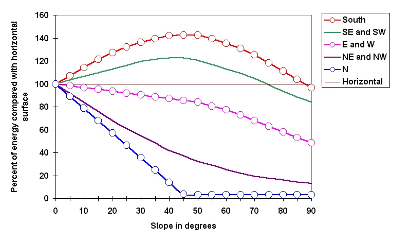
curve standing for North becomes South, South-East and South-West becomes North-Eeast and North-West, etc.. Also note that the curves go through a maximum at the slope that corresponds to the latitude, i.e. the closer the station is to the equator, the “flatter” the curves get: near the equator, steep slopes receive relatively less energy than gentle slopes, which is the reason why the figure indicates percentages rather than absolute radiation values. In the northern (southern) hemisphere, some slopes facing the south (north) never receive direct sunlight
Rainfall and water balance
Because of the mechanism explained above, atmospheric water tends to precipitate when an air mass is lifted and cooled when it reaches a mountain range. Windward slopes typically received significantly more rains than the leeward slopes. This is particularly spectacular in monsoon climates when some stations at the foothills of the Himalayas are among the wettest locations on Earth (Cherrapunji, India, 10600mm per year). The same phenomenon occurs as well in other continents, albeit in a less spectacular fashion: la Vuelta, Colombia, records 9050 mm per year and Douala, Cameroon, 3800 mm.
Mount Kilimanjaro, situated at 3 degrees Southern latitude, is exposed successively to the SE monsoon and to the NE monsoon, resulting in the East facing-slopes being significantly wetter than the Western ones, some of which are actually semi-arid. Kilimanjaro illustrates another well known features of rainfall in mountains: once all the precipitable water has been removed from the atmosphere, rainfall decreases again, so that, similar to the “warm belt” just above temperature inversions, many mountains also display a “wet belt”, usually at elevations significantly higher than the “warm belt”.
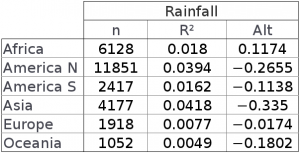
Rainfall variability according to elevation is not so straightforward as might be expected. In general, at the continental scale, rainfall tends to decrease with altitude (see table 3), because air masses lose their water before they reach the highest mountains. This is very evident if considering the arid high-mountain areas in central Asia and elsewhere. The distance to the ocean and elevation thus play an important part in rainfall distribution in mountains. Remember that the monsoon comes from the east, alternatively from the SE in the northern hemisphere summer, and from the NE during the N hemisphere winter, which is why the northern tropics have their rainy season centered around july-August (Sahel), while the rains fall around October-March in the southern hemisphere. Appendix 1 illustrates this behaviour in the case of Kilimanjaro.
When mountains are not very high, like most mountains on the African continent – except Kilimanjaro -, the temperature drop with elevation is not sufficient to remove all precipitable water from the atmosphere, with the consequence that on average rainfall increases with elevation (annually, about 100 mm every 1000 m). In Asia and South America, in spite of the wet belts, the general tendency is a decrease of rainfall with elevation, of the order of 300 mm every 1000 m in Asia and 100 mm per 1000 m in Latin America. Depending on elevation and latitude, a sizeable fraction of precipitation can be in the form of snow. In Europe, for instance, elevations above 3600-3800 receive only snow.
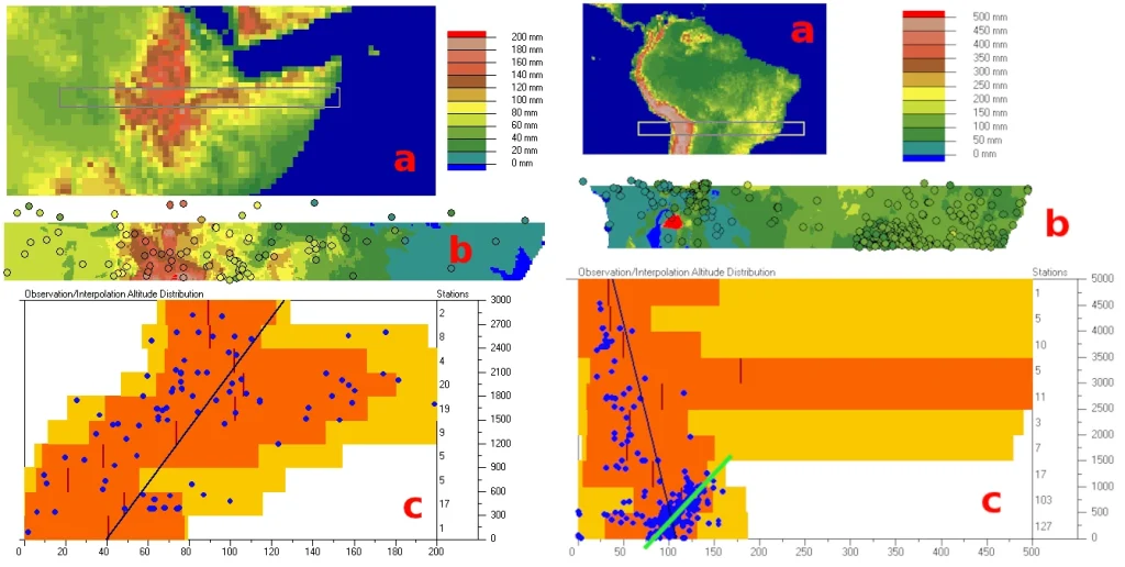
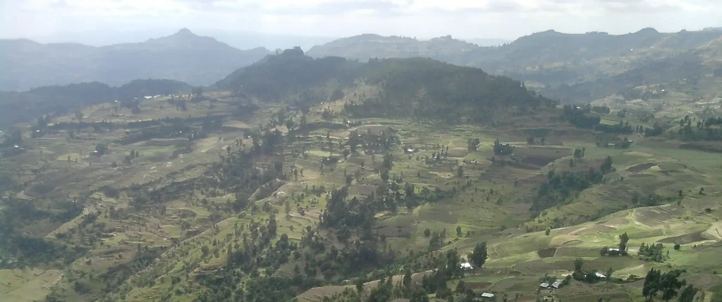
Two contrasting examples of altitudinal variation of rainfall are illustrated in Figure 5. In East Africa (4a) , precipitation increases with elevation: the mountains (or high plateau) of Ethiopia is relatively close to the Indian Ocean where the atmospheric moisture originates. On the other hand, in South America (4b), the Andes are far from the ocean, which leads to most moisture being precipitated out of the atmosphere before the air masses reach the mountains. Observe, however, that in Latin America, the positive gradient of rainfall with elevation holds up to about 1500 m (green line superimposed on (c). This corresponds to middle mountains where indeed the conditions are more favorable than in the lowlands, and also explains why the Huari fared better than their lowland counterparts (refer to the long quote from Keys above).
Snow constitutes a sizeable storage of water during the cold season. The water will be released more or less gradually when snowmelt sets in, and privides a reliable supply of water for micro-irrigation in many semi-arid countries (i.e. Afghanistan). In addition, potential evapotranspiration (the atmospheric water demand) also undergoes altitudinal changes. In spite of usually dryer air, the effect of temperature results in ETP decreasing by 100 to 200 mm (annually) per 1000 m of elevation (Table 2). The result is that relatively little water will be evaporated at high elevations: soils will often be wet, accumulate organic matter and provide a regular supply of water to the surrounding lowlands. The presence of peat at high elevations indicates locations where biomass accumulates faster than it decays, which is a consequence of the excess of rainfall over evapotranspiration, a large daily thermal amplitude and, of course, low winter temperatures which further prevent the decay of organic matter (call it deep freezer effect!)
Because of low temperatures, growing seasons are usually much shorter at high elevation than in the surrounding lowlands, but plant growth can be intense during the growing season because of a favourable radiation climate and a marked contrast between day-time and night-time temperature, as indicated (reduced respiratory loss during night-time). Needless to say, frost risk also increases with elevation and may counterbalance the positive effect of more reliable water balance conditions. The rule of thumb is that there is frost risk when the monthly average temperature drops below six or seven degrees, although this figure can vary considerably depending on atmospheric moisture conditions, cloudiness and some other factors.
Appendices
Appendix 1: kilimanjaro rainfall
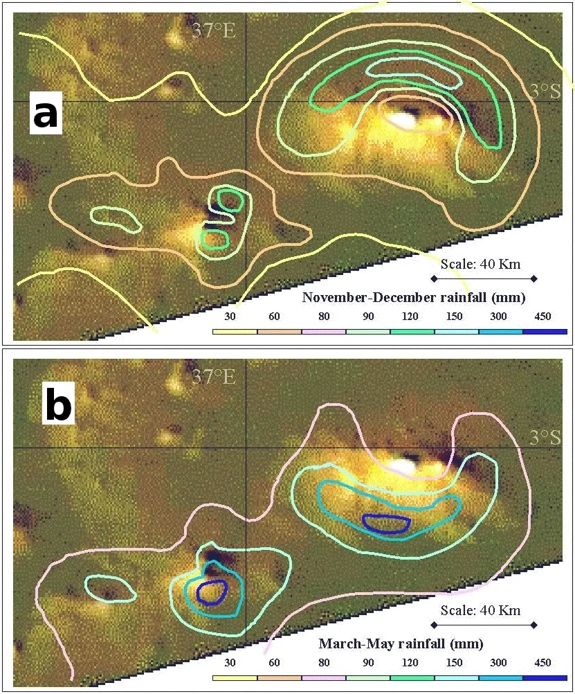
Figure 6 illustrate two points. (1) Mount Kilimanjaro, which is located about 300 km west of the Indian Ocean, receives rainfall through the NE and SE monsoon, which affect the distribution of rainfall in turn; (2) rainfall amounts are higher on the slopes that at the top of the mountain.
During the “short rains”, about October to January (Figure 6a) Kilimanjaro gets the NE monsoon. The S and the W of the mountains record relatively little rain, and the maximum rain (about 150 mm during November and December) is recorded on the N slope, while the top of the cone gets only 60 mm or so. During the “long rains” (about March to May, Figure 6b), the rain is coming from the South-East. This time, is the N slope that gets little rain. The top gets about 80 mm, while some areas on the Southern slope record more than 450 mm in March to May. Needless to say, this pattern is reflected in the vegetation and in the distribution of agriculture, mostly concentrated to the S and W.
Appendix 2: Frost in mountains
For an introduction into the subject of frost and agriculture, see Snyder and Melo-Abreu (2005); consult this link for air density and density-elevation relations. Also consult Meyer, 1999.
Predicting frost occurrence in complex terrain is no easy task, as a number of factors play a part, including air moisture, cloudiness and topography (which includes slope and aspect, but also many micro-features of local terrain). To understand the role of air moisture, it is necessary to know that atmospheric pressure is made up by the partial pressures contibuted by various atmospheric components, starting with nitrogen, oxygen, trace gases and, of course, water vapour. Average atmospheric pressure is about 1013 hPa (hectopascal) at sea level and the contribution of water vapour makes up about 2% of it (around 20 hPa). The maximum amount of water vapour that air can hold at a given temperature is the “saturation vapour pressure.” There is a simplified formula to compute saturation vapour pressure (Ps) from temperature T that was first derived by Tetens, a German meteorologist3. One of the variants of Teten’s formula used by Snyder is given below:
Ps = 61.08 × exp( T / ( T + 237.3 ) × 17.27 ) in hPa
Values are about 42 hPa at 30 degrees (deg), 23 hPa at 20 deg, 12 hPa at 10 deg and about 4 hPa below 0 deg (down to -15 deg and below). How are air moisture and temperature connected? Assume it is 5 pm and we are in a hilly landscape. Assume that the mass of air around the top of the hill is at 20 deg and that its water vapour pressure is 12 hPa. The relative air moisture is thus 12/23 or 52.17%. Air temperature decreases throughout the night until it reaches the dew point, i.e. the temperature of 10 deg where the maximum amount of moisture that can be held in the air is 12 hPa. As the environment continues cooling, water will condense out of the atmosphere. Just as evaporation of water absorbs heat, condensation (as dew or rainfall) releases heat, which is why the temperature remains relatively stable as long as water condenses. This is the mechanism by which minimum temperature is controlled by air moisture in wet places. Also observe that at constant temperature, dry air is denser than moist air (this is because the molecular weight of water (H20, 16+2 = 18) is less than the molecular weights of oxygen (O2: 32) and nitrogen (N2: 14). As a result, cool air will start flowing downhill and accumulate in low-lying areas, where there will thus be frost risk once that air moisture has reached 5 hPa.
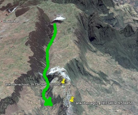
There are, basically two types of frost, known as radiation frost and advection frost (Consult Snyder and Melo-Abreu, 2005). Advection occurs when air flows in from a neigbouring place. For instance, irrigated crops in the Nile valley grow in relatevly high moisture that derives from the evapotranspitaion of irrigation water. But air moves both horizontally and vertically, and dry air is often advected from surrounding desert areas. Similarly, cold air is advected to valley bottoms where it may lead to temperature inversions. The word “flow” is used intentionally because dry air does actually behave like water when it flows downhill (see Figure 7): it flows around obstacles; some crops that are protected by a wall or dense vegetation may not be harmed, while those that stand on the way of the flow will freeze. This explains the importance of micro-topography in frost risk, a factor that is well known by farmers who have learned to avoid areas exposed to cold air currents.
Radiation frost occurs typically during cloudless nights: the soil radiates heat (longwave) into the atmosphere. Clouds do intercept the heat and radiate part of it back, which reduces frost risk.
In general, moisture (including soil moisture and abundant dew) provides some protection against frost, because freezing water releases heat and prevents large ice crystals from forming inside plant cells4. Paradoxically, one of the techniques to protect crops from frost is this to irrigate, sometimes with sprinklers: the ice that deposits on plants protects them from frost. There are several other techniques; many of them aim at preventing air from stabilising (using fans or fires) but they are difficult to implement for field crops such as cereals. And then, as was mentioned, walls or other structures can be built to deviate the flow of cold air. In the end, however, the most inexpensive protection is to avoid frost prone places!
References
Dorst, J., C. Favarger, R. Hainard, O. Paccaud, P.C. Rougeot, J.P. Schaer, P. Veyret. 1973. Guida del naturalista nelle Alpi. Zannichelli, Bologna. 333 pp.
Guyot, G. 1999. Climatologie de l’Environnement, Dunod, Paris, 525 pages.
Hood, E., M. Williams & D. Cline. 1999. Sublimation from a seasonal snowpack at a continental, mid-latitude alpine site. Hydrol. Process. 13:1781-1797.
Jackson, I.J., 1977, Climate, water and agriculture in the tropics, Longman, London and New York, 248 pp. THis is one of the best books I came across on the subject.
Keys, D. 1999. Catastrophe, an investigation into the origins of the modern world. Balantine, 352 pp. The Kindle edition (the one I read!) appeared in October 2000.
MacDonald, M.K., J.W. Pomeroy & A. Pietroniro. 2010. On the importance of sublimation to an alpine snow mass balance in the Canadian Rocky Mountains. Hydrol. Earth Syst. Sci., 14:1401–1415
Meyer, W.S. 1999. Standard reference evapotranspirationcalculation for inland, southern Australia.CSIRO Technical Report 35/98. 30 pp. http://www.clw.csiro.au/publications/technical98/tr35-98.pdf Also has some FORTRAN routines that may be of interest.
Pomeroy, J., N. Hedstrom & J.Parviainen, 1999. The Snow Mass Balance of Wolf Creek, Yukon: Effects of Snow Sublimation and Redistribution. In: Wolf Creek Research Basin – Hydrology, Ecology, Environment (Proc. workshop held in Whitehorse, Yukon, Canada, 5-7 March, 1998), 15-29. NHRI publication 37-121/1999E, Saskatoon, Saskatchewan, Canada. Available online.
Snyder, R.L. & P. Melo-Abreu. 2005. Frost Protection: fundamentals, practice, and economics, Vol. 1. FAO Environment and Natural Resources Series, 112 pp. Available on the website of FAO, also in pdf format. Appendix 3 provides information about humidity calculations. Vol. 2 focuses on economic impacts.
von Denffer, D., W. Schumacher, K. Mägdefrau, F. Firbas. 1967. Lehrbuch der Botanik für Hochschulen, begründet von E. Strasburger, F. Noll, H. Schenck, A.F.W.Schimper. 29. Auflage. G. Fischer Verlag, Stuttgart. 762 pp.
Notes
- This post about mountain climate is an updated and expanded version of an earlier text I wrote for the website of FAO many years ago (July 2002). Since then, I have left FAO for JRC where I have actually started working on climate related risk issues in a rather mountainous country (Ethiopia)… which somehow improved my perception of some specific issues. ↩︎
- Different technical fields have different interpretations for the terms micro, meso and macro. Climatologists use “micro” to describe “local” conditions, for instance the climate in a valley, or any climate that differs from the “general” (macro, or zonal) climate. For an ecologist, “micro” tends to be much smaller. It would apply, for instance to soil climate, the climate of a tree bark, a crevice in rocks or the fleece of sheep. A biologist would tend to use “macro” for the scale of an ecosystem which would roughly be a region that the climatologist would rank under “meso”. Clealry, biologists need a larger scale that “macro”, and that would probably be “global” ↩︎
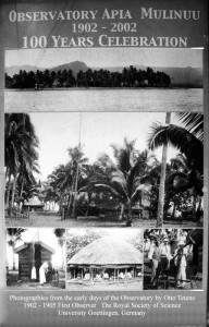
- It is difficult to find detailed biographical information about Otto Tetens (1865-1945). The English Wikipedia has some lines, while the German version is a bit more detailed. Tetens’ main interest was astronomy and between 1902 and 1905, he installed the Geophysical Observatory in Apia, then part of German Samoa. In fact, Tetens is mainly remembered for his photographs! A poster prepared for the 100th anniversary of the Mulinuu Observatory uses some of Tetens’ photographs (Figure 8). For more early Samoa photographs by Tetens, see link in Wikipedia. ↩︎
- Large crystals mechanically destroy plant structure, which explains why some particularly fragile plants look as if they had been boiled after frost: their colour darkens and they become flaccid. ↩︎
