This project aims at describing some features and trends affecting weddings in the Eifel, including their geography i.e. finding out, for instance, how far away from home brides would marry. This assumes that the home places can be identified and assigned geographic coordinates. It turned out this is far from a simple or immediate task, and that it requires a significant time investment. Since a very large number of localities occur only once, it was decided to base the study on a sample rather than the entire database, with little loss of statistical significance.
EXTENT.1 The overall working database
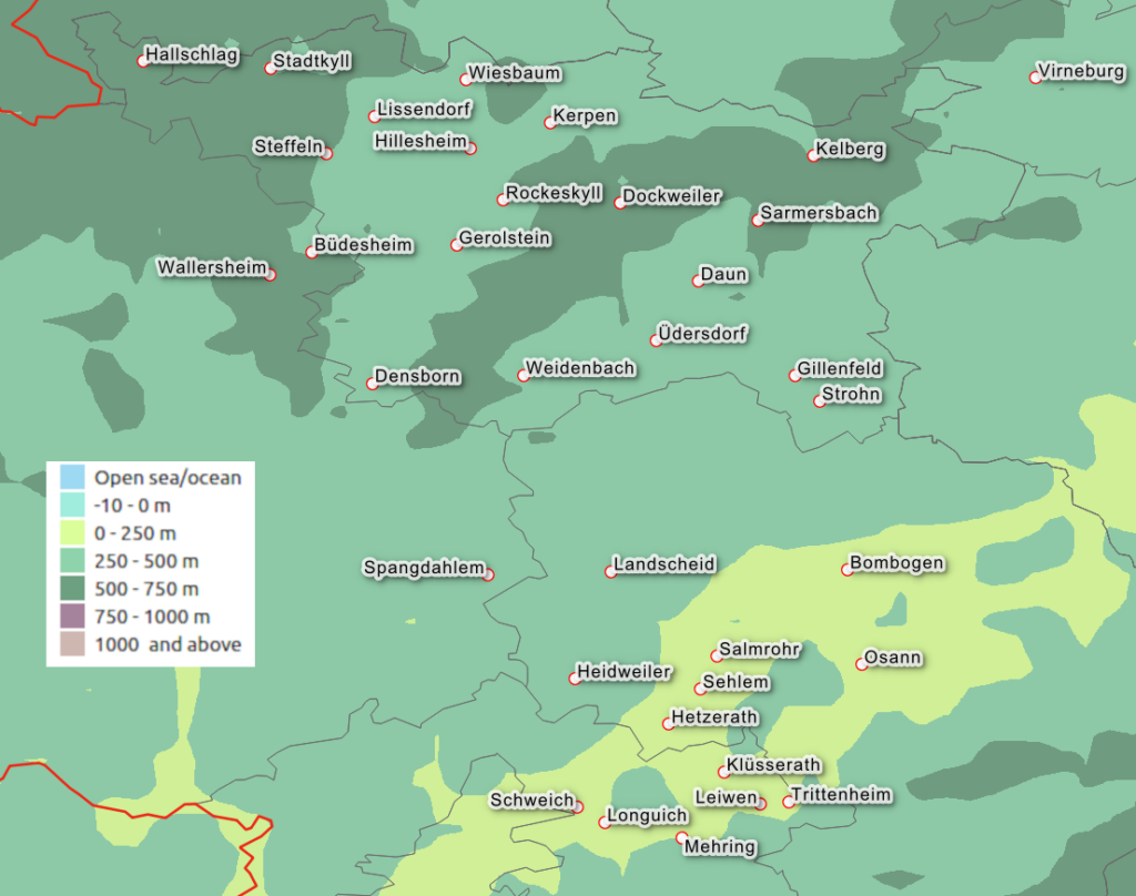
All data were downloaded from the website of Karl-Josef Tonner (KJT) at the end of January 2022. They correspond to 35 localities which are shown in the map (EXTENT-F01) below. 35 files, one per locality (i.e. civil registry offices, Standesamt) were combined into the projects database, which was not updated nor expanded after the original download, even if KJT made more data available.
Most Registry offices belong to the Landkreis (Administrative district) Vulkaneifel (capital: Daun). Other districts include, to the North-East, Mayen-Koblenz with Virneburg (capital: Koblenz); on the South-East we have the Landkreis Bernkastel-Wittlich (capital: Wittlich) with Bombogen, Heidweiler, Hetzerath, Landscheid, Osann, Salmrohr and Sehlem . Further South we find the Landkreis Trier-Saarburg (capital: Trier) with Klüsserath, Leiwen, Longuich, Mehring, Schweich, Trittenheim and eventually, in the West, the Eifelkreis Bitburg-Prüm (capital Bitburg) with Büdesheim, Wallersheim and Spangdahlem. All the mentioned places and districts can be found on Wikipedia for additional information. The districts belong to the Land (State) of Rhineland-Palatinate.
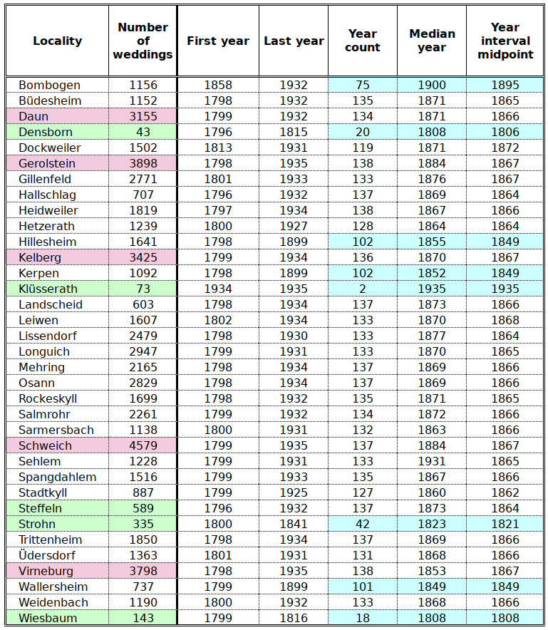
The database contains few pre-1800 data. The ones that were retained span the period from 1799 or 1800 to the first half of the 1930s; . They include 59616 weddings, with the largest numbers belonging to Schweich and Gerolstein; details are listed in the table below . With the exception of Densborn and, especially Klüsserath, the record is of good quality, with the length of the record in excess of 130 years. In most cases, the interval mid-point and the median are very similar, indicating that the years are evenly distributed over the whole time interval, with a relative excess of late years in Gerolstein and of early years in Virneburg.
For the analysis of time trends, only locations with time series exceeding 100 years and ending after the first World war were retained, the places marked in blue below were ignored: Bombogen, Densborn, Hillesheim, Kerpen Klüsserath, Strohn, Wallersheim and Wiesbaum.
EXTENT.2 Information available for each wedding
The Locality files were assembled into one large file, usually containing the following information for each of the 59616 weddings:
- Place of wedding (one of the 35 localities above)
- A code assigned by KJT, made up by the year followed by a serial number
- Date of marriage
- Last name (family name, surname) of groom
- First name (given, christian name, forename) of groom
- Birthplace of groom
- Last name of bride
- First name of bride
- Birthplace of bride
EXTENT.3 Number of “raw” place names
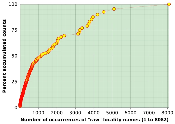
The number of places of origin of the spouses and the number of place names in the KJT database are vastly different issues. After a first quick correction of some common orthographic variants including ue to ü1 and K to C2, etc. there are about 4570 unique place names, which are referred to as “raw” place names. 154 occur more than 200 times. This is not necessarily 200 weddings as the bride and groom often hail from the same locality. The list is topped by Schweich (8082 occurrences), Gerolstein (5098 occurrences), Mehring (4536 occurrences), Virneburg (4203 occurrences) and Daun (3957 occurrences). More than half of the “raw” place names (2751) appear only once; 486 are mentioned two times and 203 three times etc. The graphs below illustrate the statistical distribution of the frequency of “raw” place names.
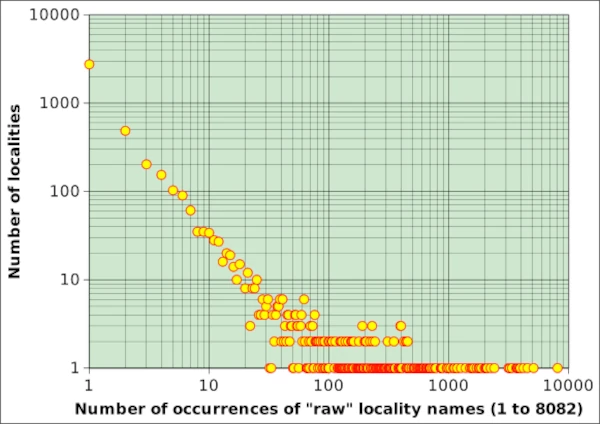
The highest value on the ordinate is 2751, as 2751 raw locality names occur only once; the next point is 486: 486 places occur twice; 34 localities occur 10 times. There is only 1 locality that occurs 8082 times (Schweich), the rightmost point on the abscissa. The second point on the high end of the abscissa is Gerolstein, 5098 occurrences, etc).
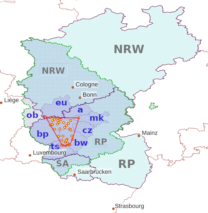
EXTENT.4 The Project “hull” or “polygon”
The Project “hull”, sometimes referred to as the Project “polygon” is the convex hull (or envelope) of the points representing the localities in the table listed above. This is a standard concept in Geographic Information Systems (GIS). It is represented in red in the figure below, together with the 35 localities where the marriages included in the database took place. The area included in the hull is just short of 1700 km² and its perimeter is about 180 km. As indicated with more detail in table WEDNUM-T01, which provides some data taken from the 1885 census, the hull included 212 villages, just above 67000 people with a density of 49 km⁻². Land-use covers mostly crops (36%) and woods (34%). The total area of the villages (1359 km²) is less than the one included in the Hull.
The district where most of the weddings took place (Vulkaneifel) occupies the northern half of the polygon and is not identified by any symbol. ob represents the combined territories of Ostbelgien and the former Prussian Wallonia (German, French), which were part of the Prussian Rhine Province. Only one district (Kreis) is indicated in NRW (eu, Euskirchen); the others are, clockwise in RP, a Ahrweiler, mk Mayen-Koblenz, cz Cochem-Zell, bw Bernkastel-Wittlich, ts Trier-Saarburg and bp, Bitburg-Prüm.